Floresville
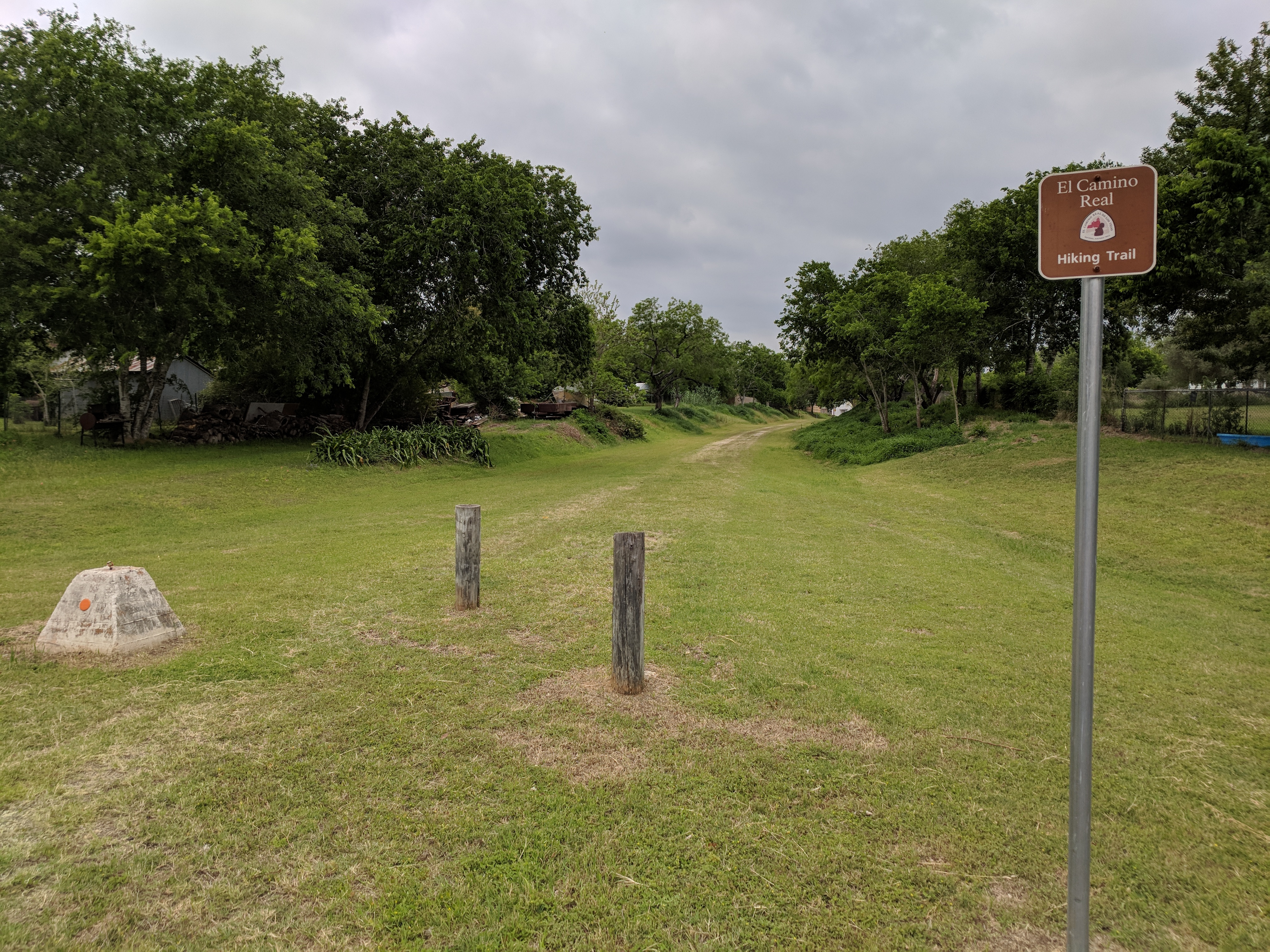
Floresville El Camino Trail
This trail is located on the old San Antonio and Aransas Pass Railroad right-of-way, and it roughly parallels the 19th-century El Camino Real de los Tejas between San Antonio and Goliad.
Located: 763 Trail St, Floresville, Texas, 78114
Floresville Texas Website
Rancho de las Cabras
This ranch is listed in the National Register of Historic Places and is associated with Mission San Francisco de la Espada, whose ruins include standing walls. It was located on the west bank route of the Béxar–La Bahía Road. (National Park Service)
Contact National Park Service for tours.
Texas State Historical Association
Goliad
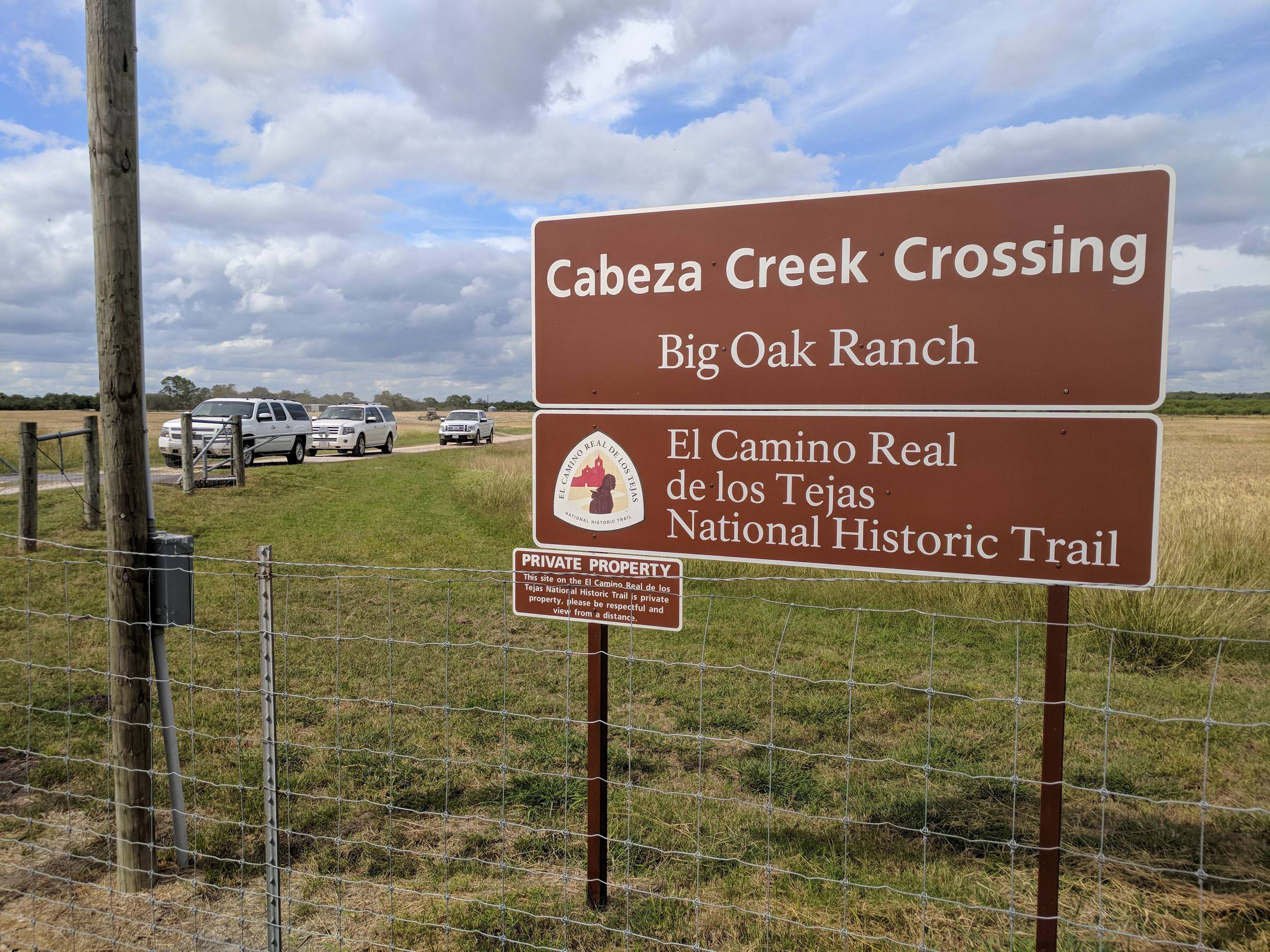
Cabeza Creek Crossing Historical Marker
Part of a National Historic District, this is a gravel bar ford on Cabeza Creek that may have been associated with the Béxar-La Bahía Road. Artifacts recorded for the site are American Indian – likely prehistoric, but could also be protohistoric or historic. Swales stretch on both sides of the crossing.
Mission Nuestra Señora del Espíritu Santo de Zúñiga
“The Spanish began colonizing efforts in what is today South Texas after withdrawing to El Paso in the wake of the Pueblo Revolt of 1680. Colonization of the area was politically and economically advantageous. In addition to saving souls, the missions were a way to create a supply of native labor and deter the French in Louisiana from gaining a foothold in the region. Founded as part of that colonial venture, Mission Nuestra Señora de la Bahía del Espíritu Santo de Zúñiga, often called Mission Espíritu Santo, was established by Franciscan priests in 1722 and was moved three times. Its final and current location is near Goliad, Texas. Now the mission is a part of Goliad State Park and Historic Site and is listed in the National Register of Historic Places. The history of the mission is exemplary of the geopolitical tensions in the region and the emergence of ranching culture in Texas.”
Located: 108 Park Road 6 Goliad, TX 77963-3206
National Park Service
Goliad State Park
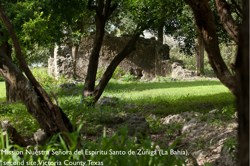
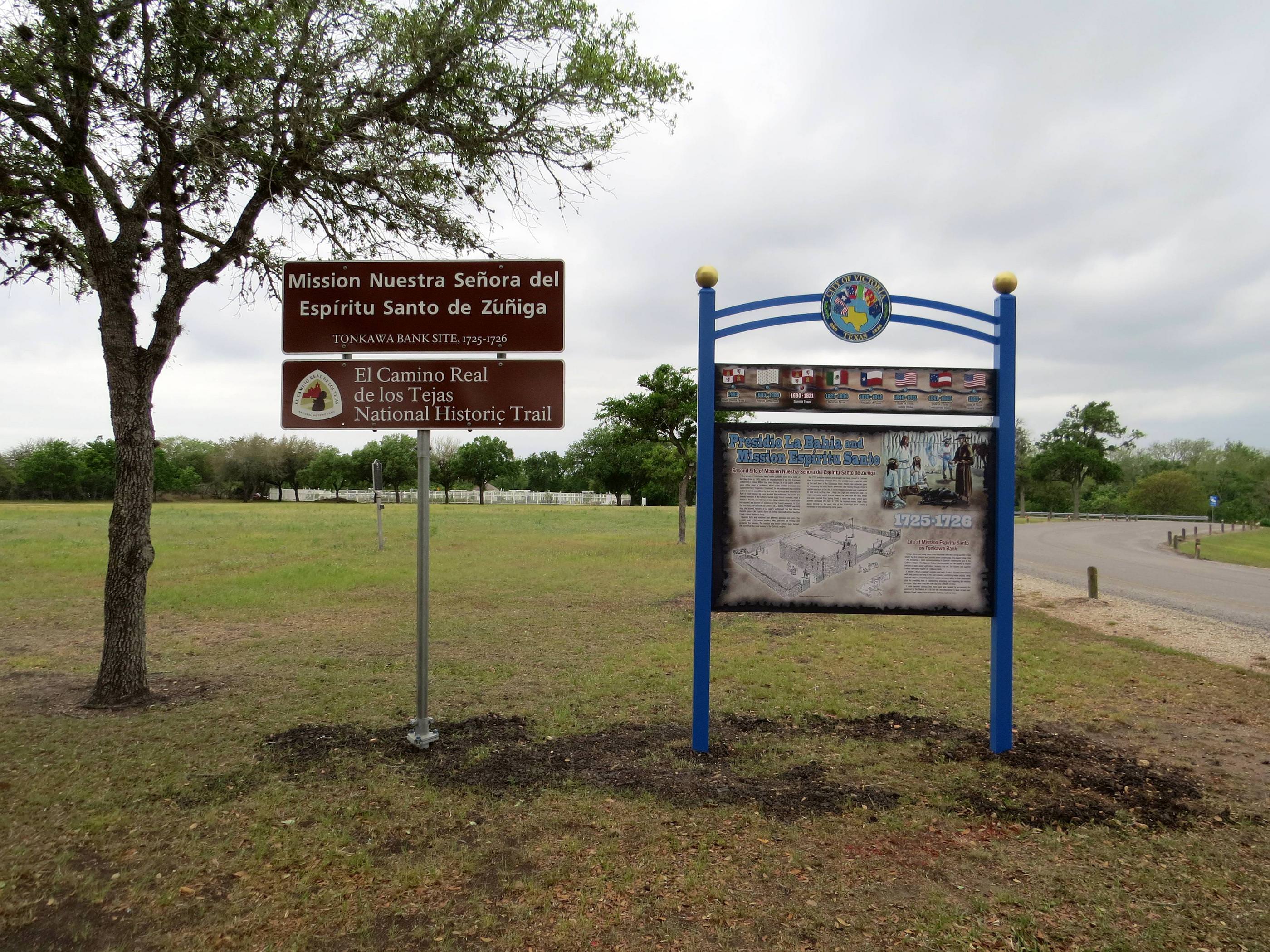
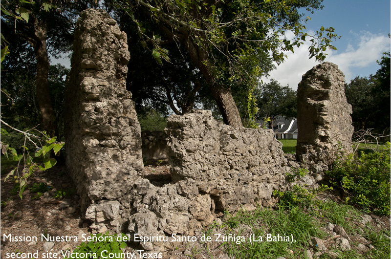
Mission Nuestra Señora del Espiritu Santo de Zúñiga (Tonkawa Bank), 2nd Site
Historical Marker
This mission is listed in the National Register of Historic Places. It was moved from the original location on Garcitas Creek around 1726. It was constructed of mortared stone on a bluff called Tonkawa Bank near a popular low-water crossing. The original mission, which appears in Spanish records also as La Bahía del Espíritu Santo de Zúñiga, was a reference to its location on La Bahía del Espíritu Santo (the Bay of the Holy Spirit, now called Matagorda Bay and Lavaca Bay) and also honored Báltasar de Zúñiga, viceroy of New Spain. The establishment remained at its original site only about four years and was relocated at least twice. As early as April 1725 the padres recommended moving it and its presidio to a location more favorable to their missionary efforts. They had been unable to induce the wandering Karankawas to accept Christian teachings or stay at the mission, and there had also been incidents of ill feeling and violence between the Indians and the Spaniards. (National Park Service)
Located: 501 McCright Dr, Victoria, TX 77901
Mission Nuestra Señora del Espiritu Santo de Zúñiga, 3rd site
Private Property
First established at Garcitas Creek by the Marques de Aguayo and Father Fray Agustin Patron, O.F.M. in 1722. Moved to Mission Valley in 1726. Maintained here by the Franciscan missionaries for the Christianizing and civilizing of the Jaraname and other Indians. Finally moved to present Goliad in 1749. (Texas Historic Commission)
Located: 3377 Lower Mission Valley Rd, Victoria, TX 77905
Texas State Historical Association
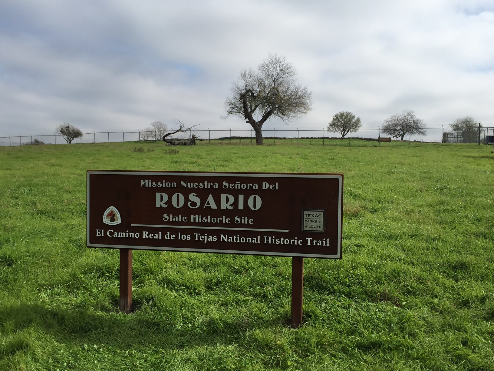
Mission Nuestra Señora del Rosario de los Cujanes
This National Register property was established in November 1754 by Father Juan de Dios Camberos in an attempt to make peace with the various Karankawan tribes, who had been troublesome to the Spaniards since the early eighteenth century. The first buildings were made of timber and whitewashed clay; later, stone and mortar were used. Indians came to the mission from time to time but were reluctant to stay, especially when supplies gave out. They were difficult to control, and the fathers complained of their indolence. The Indians came to the mission in the winter, but most left when spring came and they could produce their own food. By 1781 the mission was virtually abandoned. Father José Mariano Reyes reopened it in 1789 and built a small hut and a log chapel among the ruins. In 1791 a new church of stone and plaster was completed. The Indians had argued for a mission closer to their homes, and as a result Nuestra Señora del Refugio Mission was established in 1792. In 1797 all the Cocos at Rosario went to Refugio. By 1804 the buildings were in need of repair, especially after heavy rains caused part of the front to collapse. After failing to obtain money for repairs, Father Huerta, the missionary in charge, took the remaining Indians to Refugio. On February 7, 1807, Rosario was formally combined with Refugio.
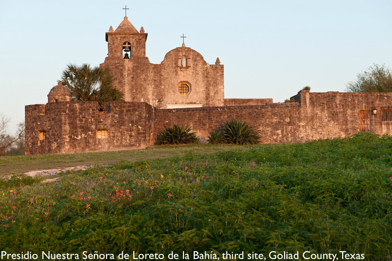
Presidio Nuestra Señora de Loreto de la Bahía
“The Presidio Nuestra Señora de Loreto de la Bahía (Presidio de la Bahía) served the people of four independent nations: Spain, Mexico, the Republic of Texas, and the United States, and is recognized for its cross-cultural, religious, and military significance. Constructed in 1749 to protect the Spanish missions in South Texas, including the nearby Franciscan Mission Nuestra Señora del Espíritu Santo de Zuñiga, the Presidio de la Bahía is an outstanding example of a Spanish military compound. The presidio played a critical role in the development of Spanish and Mexican culture in the region and was important in conflicts that took place through the years of the Mexican Revolution (1821) and the later Texan Rebellion (1836).”
Located: 217 US-183, Goliad, TX 77963
National Park Service
New Braunfels
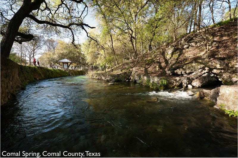
Comal Springs
“The Comal Springs are the largest in Texas and the American southwest. Seven major springs and dozens of smaller ones occur over a distance of about 4,300 feet at the base of a steep limestone bluff in New Braunfels’ Landa Park. The Springs and the Comal River below are home for a federally endangered species, the Fountain Darter. In Spanish, ‘comal’ is a flat griddle used for cooking tortillas, so the name probably refers to the flat area below the bluff where the springs issue forth. The largest and most easily visited is the one shown at left, just west of Landa Park drive.”
Located: 164 Landa Park Drive, New Braunfels, TX 78130
New Braunfels Website
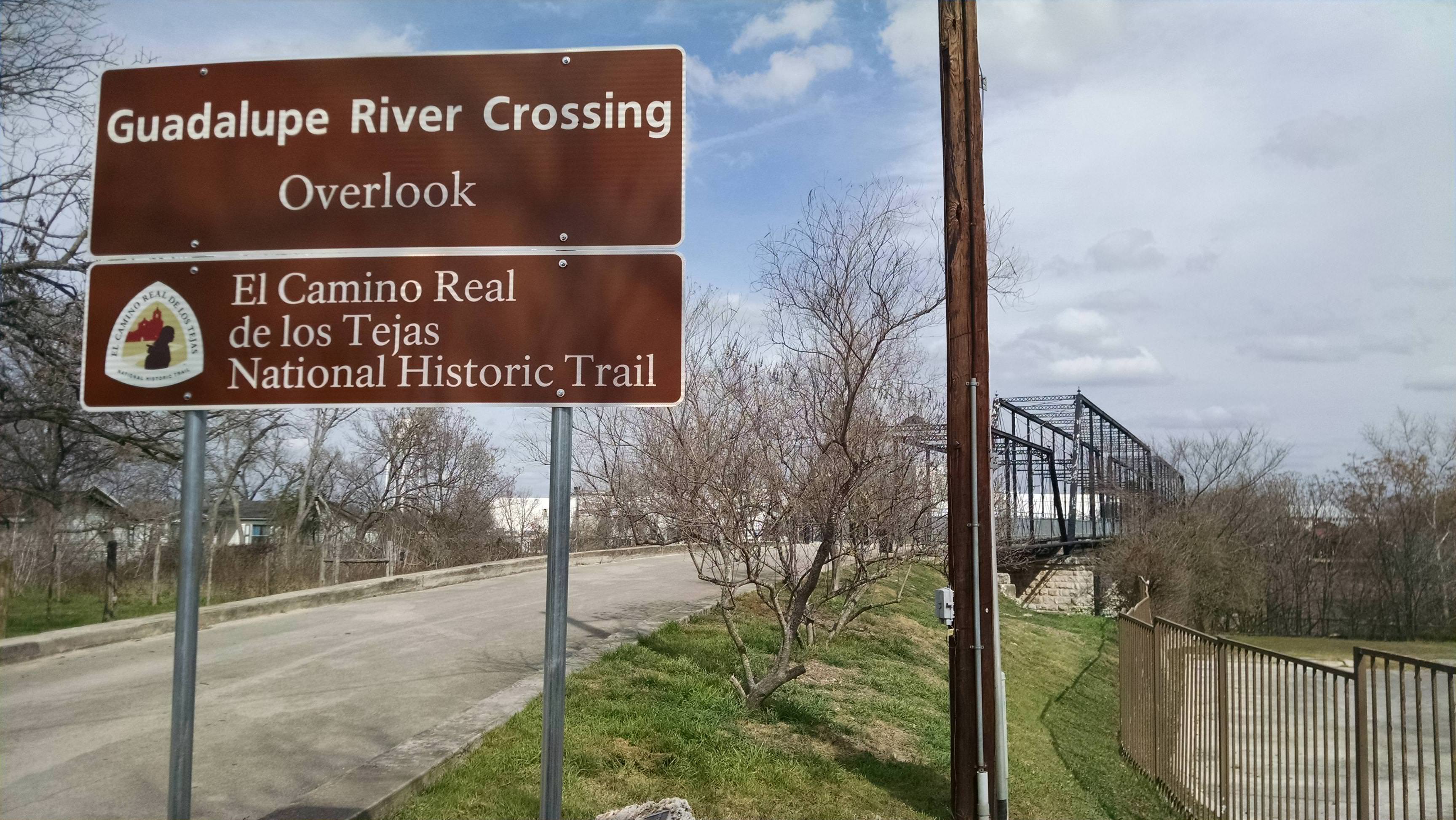
Guadalupe River Crossing
The major crossing of the Guadalupe River, was used by travelers and caravans carrying supplies to Spanish missions in East Texas. It sometimes took weeks for the floodwaters to recede so that travelers could cross.
Located: Faust Street Bridge, New Braunfels, Texas, 78130
San Antonio
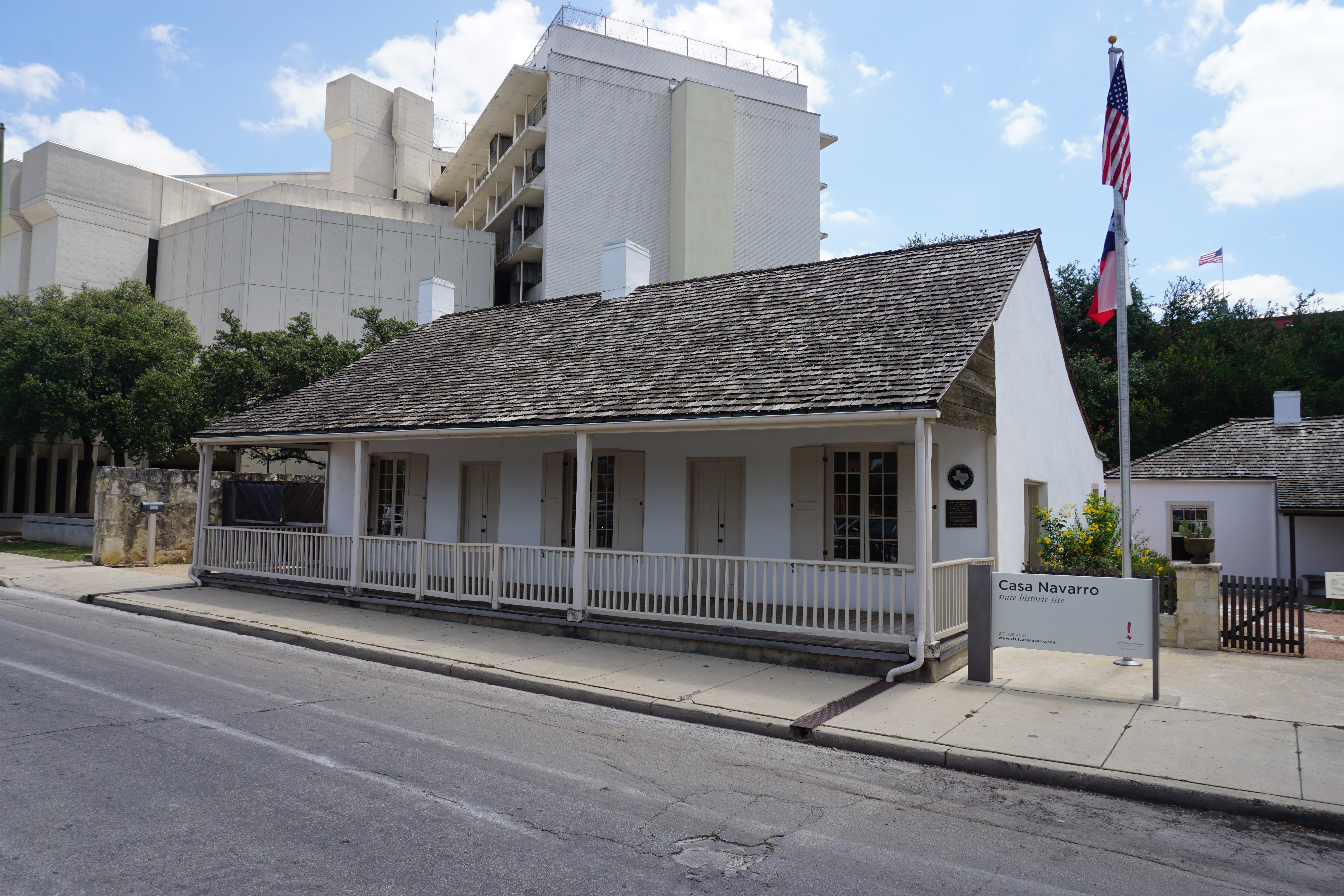
Casa Navarro House
José Antonio Navarro was an influential political figure during the momentous 55 years (1810–1865) when Texas’ destiny was forged. Navarro served in Texas legislatures under Mexico, the Republic of Texas and the state of Texas. In addition, he served on the committees that wrote the first two Texas constitutions in 1836 and 1845. (Texas Historic Commission)
Located at: 228 S Laredo St, San Antonio, Texas, 78207
Texas Historical Commission
Photo credit: Michael Barera CC BY-SA 4.0
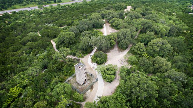
Comanche Lookout Park
Comanche lookout park is a 96-acre public park owned by the City of San Antonio. The Cibolo Creek floodplain lies at the base of this escarpment, between the Gulf Coastal Plain and the Edwards Plateau. American Indians used this hill as a vantage point for warfare and hunting. Apache and Comanche Indians dominated the area as they hunted along waterways, including nearby Cibolo Creek. The hill was also a prominent landmark for travelers in the 18th and 19th centuries. It was noted in early field survey notes and on Stephen Austin’s map. Located on the original road to San Marcos Spring, one of several routes of El Camino Real de los Tejas extended past the base of the hill. (National Park Service)
Located: 15551 Nacogdoches Rd San Antonio, TX 78247
San Antonio Parks
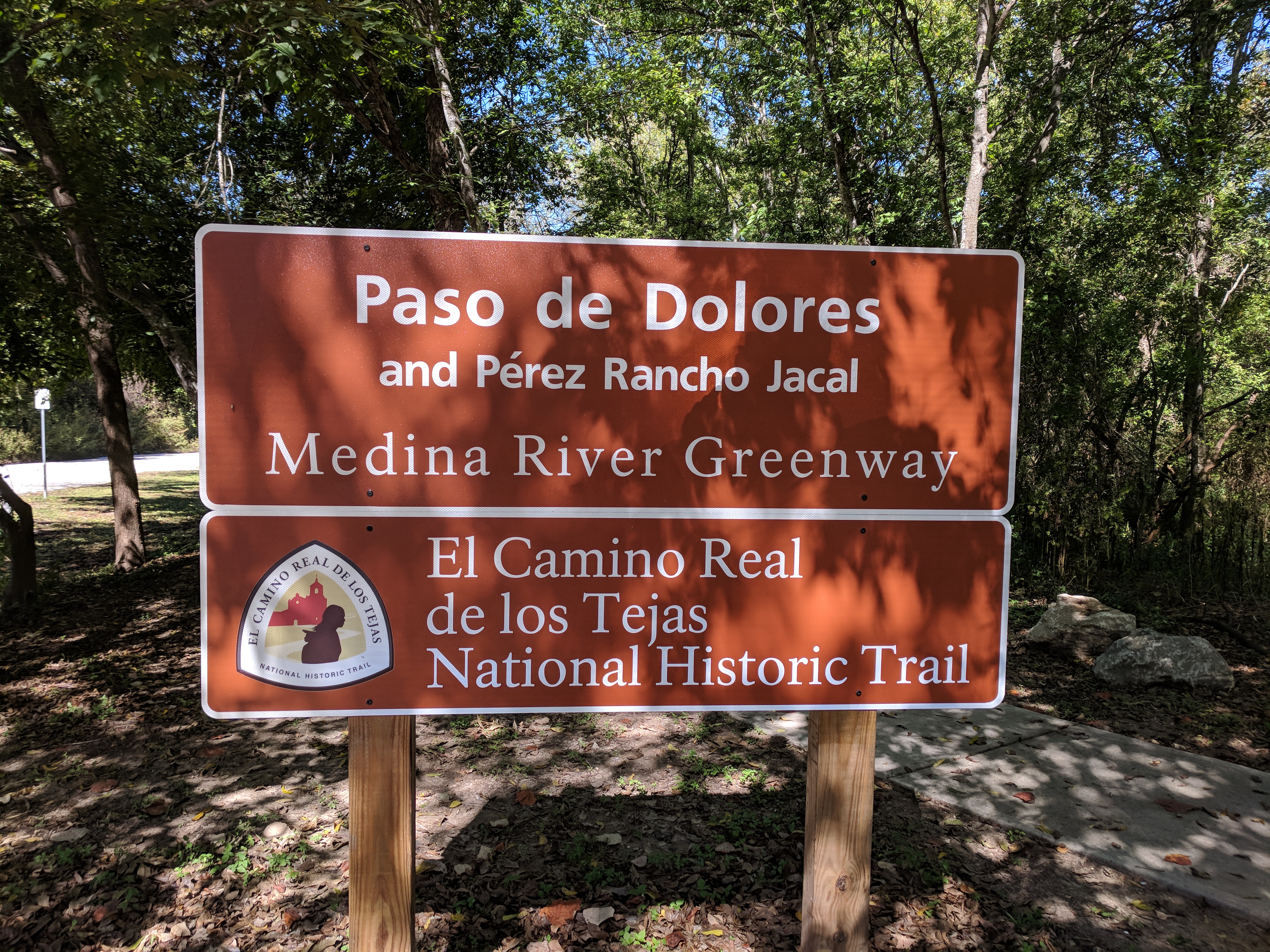
Paso de Dolores and Pérez Rancho Jacal
The property is located on a portion of the land granted to eventual Spanish Texas governor Ignacio Pérez in the 1700s, and includes one of the state’s oldest family ranches. In recent years, archaeological investigations have revealed centuries-old activity in the area, including wheel marks in creek beds at the Dolores-Applewhite Crossing that verify its use on El Camino Real de los Tejas.
Located: 2440 W Jett Rd, San Antonio, TX 78264
National Park Service Website
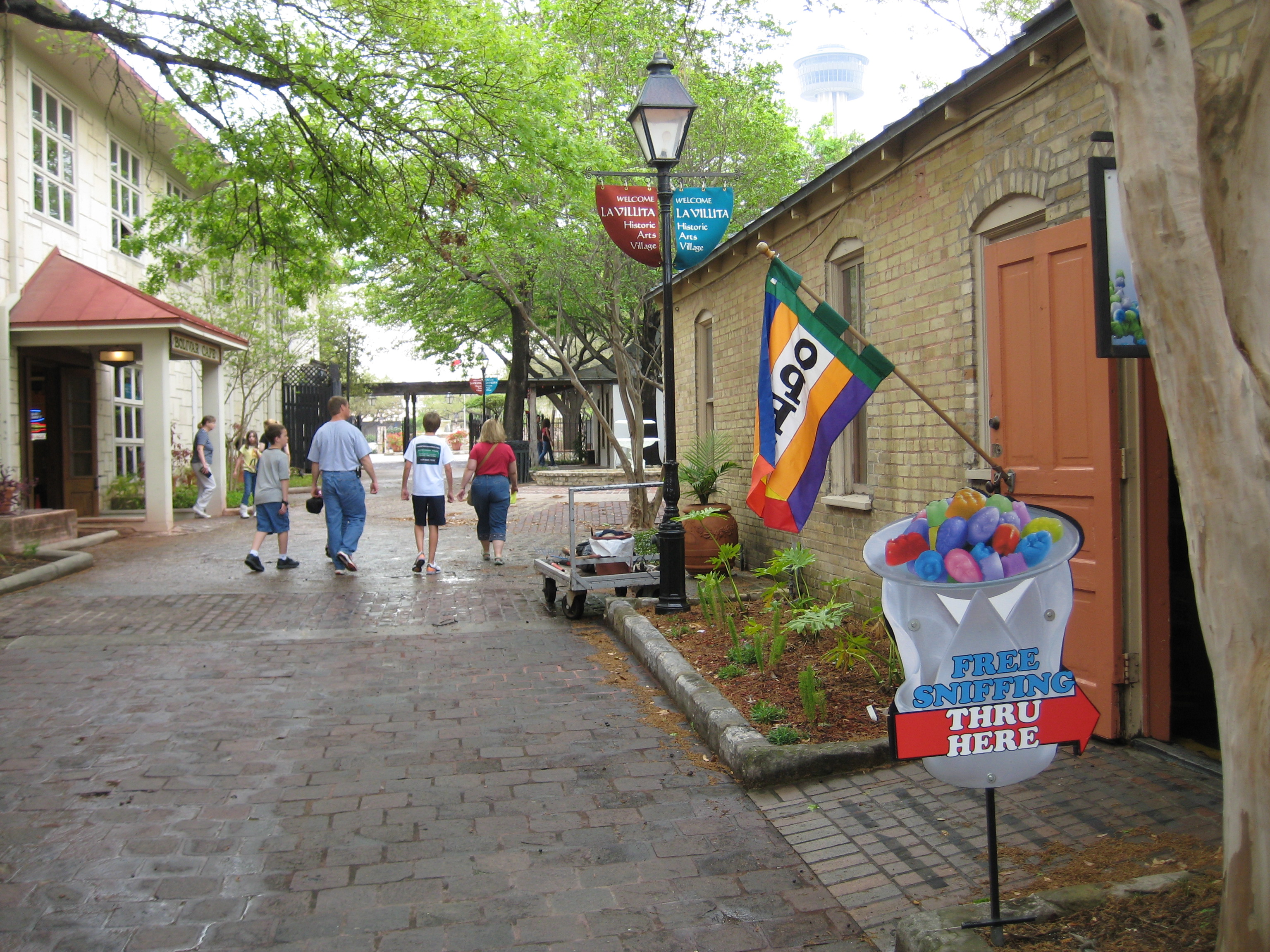
La Villita Park
Once the site of a Coahuiltecan Indian village, the La Villita Historic District portrays the building traditions of the early Mexican, European and Anglo American settlers who shaped the history of San Antonio. During the Spanish colonial period, the site was a barrio or small neighborhood, referred to as the “Town of the Alamo.” The “town” evolved from the houses constructed in the 1760s for families of Spanish soldiers attached to the San Antonio de Béxar Presidio. Because it sat on relatively high ground, La Villita began to appeal to the wealthier families of San Antonio. During the 1840s, German and later Swiss and French immigrants moved into the district, modifying the community and adding European style architecture. The La Villita Historic District preserves building types typical of early Texas architecture in the 19th century. (National Park Service)
Located at: 418 Villita St #9, San Antonio, TX 78205
La Villita Website
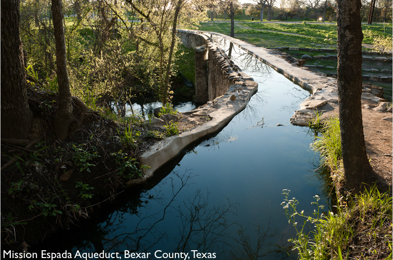
Mission Espada Aqueduct
“Since water was vital to the permanency of San Francisco de la Espada Mission, The Franciscan missionaries and their Indian followers built a dam, irrigation ditch, and aqueduct. The 270-foot dam, an engineering feat which “curved the wrong way,” was built across the San Antonio River. Lime salts in the water gradually cemented the dam’s layers of brush, gravel, and rocks. Water transported by Espada ditch crossed Piedras creek by way of the Espada Aqueduct. This, the only such structure in the U.S., was built from 1740 to 1745. The Alluvial Valley produced crops of maize, beans, melons, calabashes, and cotton. However, deterioration had set in at Espada before its secularization in 1794. Even so, the dam, ditch, and aqueduct survived a century of Indian attacks, ravaging floods, and controversy before the Espada Ditch Company repaired the dam, in 1895. In 1941, to help insure the preservation of this singular colonial aqueduct, the San Antonio Conservation Society purchased the adjacent lands. Further assurance came in 1965, when the U.S. Department of Interior designated Espada Aqueduct as a registered National Historic Landmark.” (National Park Service)
Located: 9045 Espada Rd, San Antonio, TX 78214
National Park Service
National Park Service
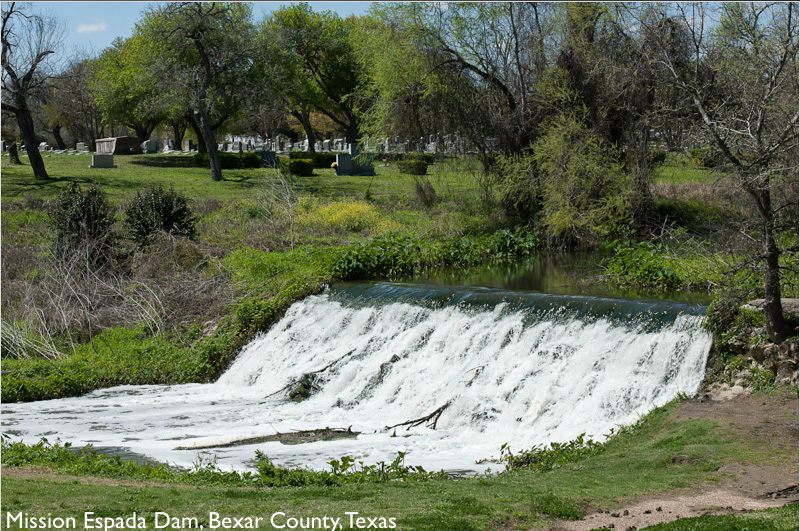
Mission Espada Dam
The missions’ need for irrigation for the crops necessitated an elaborate system of acequias, or irrigation ditches, to channel water. The Spanish constructed seven acequias, five dams, and an aqueduct, using American Indian workers. This system extended 15 miles and irrigated 3,500 acres of land. The Espada Aqueduct was constructed in 1745 by Franciscans to serve the mission lands of Espada. It is the only remaining Spanish aqueduct in the United States. (National Park Service)
Located at: 397 Mission Pkwy, San Antonio, TX 78214
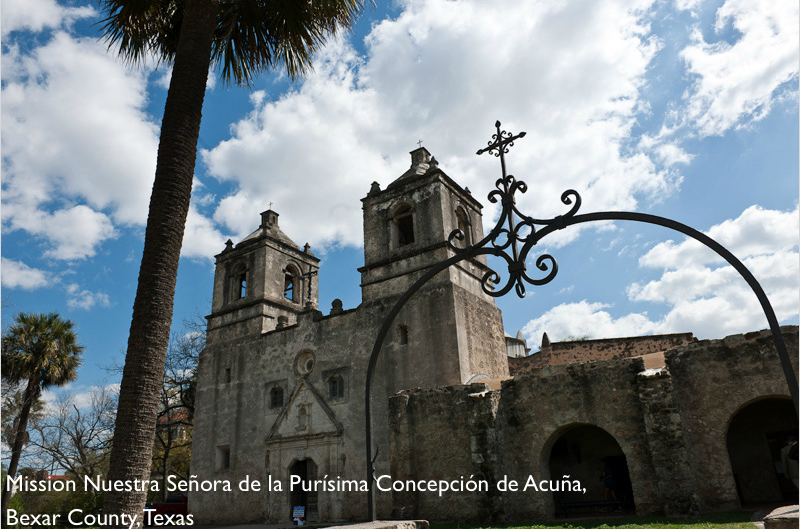
Mission Nuestra Señora de la Purísima Concepción de Acuña
“Originally founded in 1716 in what is now eastern Texas, the mission was one of six authorized by the government to serve as a buffer against the threat of French incursion into Spanish territory from Louisiana.
Developed by Franciscans and after a tenuous existence and several moves, the mission was transferred to its present site in 1731.
This handsome stone church took about 15 years to build, and was dedicated in 1755. It appears very much as it did over two centuries ago. Due to the fact that it was built directly on bedrock, it never lost its roof, or its integrity. It remains the least restored of the colonial structures within the Park.
In its heyday, colorful geometric designs covered its surface inside and out. The exterior patterns have long since faded or been worn away. However, there are several rooms in which to see remaining frescoes with all their detail and creativity.”
Located at: 807 Mission Rd, San Antonio, TX 78210
National Park Service
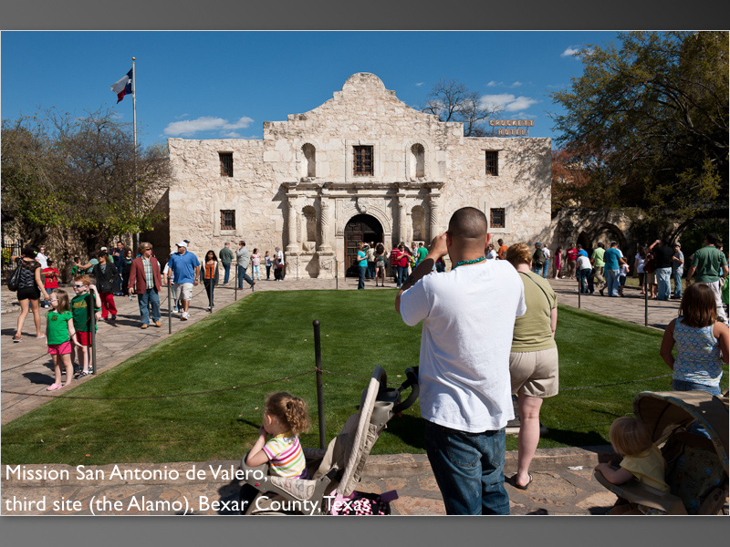
Mission San Antonio de Valero
“The meaning of places can change drastically through time. There is no better example of this transition than the remains of the mission complex established by Franciscan missionaries as Mission San Antonio de Valero in 1718. Known today as The Alamo, this Spanish mission complex was the first of the San Antonio missions founded to convert the local American Indians to Christianity. The mission eventually became a community of Spanish, Mexican, and American Indian Catholics. After it was secularized at the end of the 18th century, and during Mexican struggle for independence from Spain, the building fell into disuse. During the Texas Revolution, a small garrison of Texan soldiers defended The Alamo against the Mexican army, and their defeat and deaths became a rallying cry for Texas independence. Today the Alamo, a National Historic Landmark, is located in the heart of downtown San Antonio and remains an important part of Texas history.”
Located at: 300 Alamo Plaza, San Antonio, TX 78205
National Park Service
The Alamo
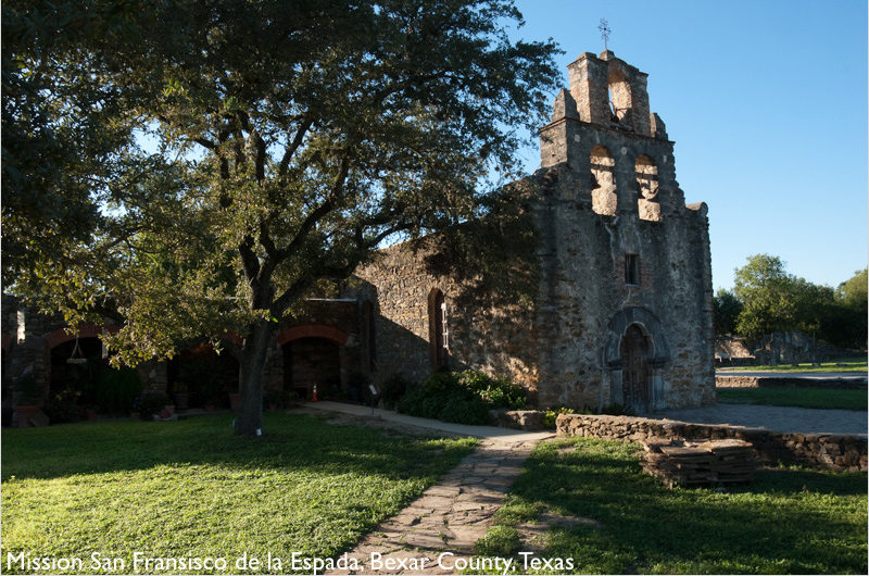
Mission Espada
“Espada’s roots lie in east Texas, where Spain founded Mission San Francisco de los Texas in 1690. Along with several others, it served as a buffer against French encroachment from Louisiana. Fevers, floods, fires, enemies, and limited supplies prompted several relocations of this early mission. On March 5, 1731, Mission San Francisco de la Espada was established along this bank of the San Antonio River. Imagine two diverse cultures – separated by language, values and faith – colliding and merging to create a unique mix.”
Located at: 10040 Espada Rd, San Antonio, TX 78214
National Park Service
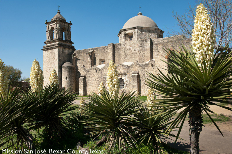
Mission San José
Known as the “Queen of the Missions”, this is the largest of the missions and was almost fully restored to its original design in the 1930s by the Works Projects Administration (WPA). Spanish missions were not churches, but communities, with the church the focus. Mission San José shows the visitor how all the missions might have looked over 250 years ago.
Located: 6701 San José Drive, San Antonio, Texas, 78214
National Park Service
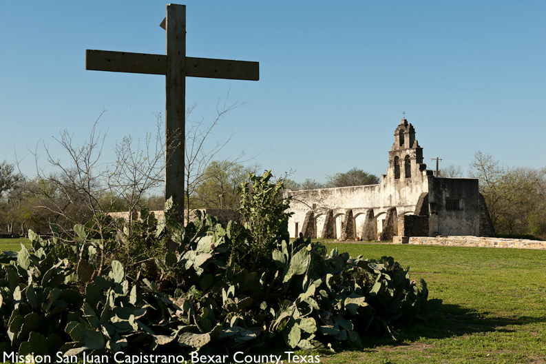
Mission San Juan Capistrano
“Originally founded in 1716 in eastern Texas, Mission San Juan was transferred in 1731 to its present location. In 1756, the stone church, a friary, and a granary were completed. A larger church was begun, but was abandoned when half complete, the result of population decline.
San Juan was a self-sustaining community. Within the compound, Indian artisans produced iron tools, cloth, and prepared hides. Orchards and gardens outside the walls provided melons, pumpkins, grapes, and peppers. Beyond the mission complex Indian farmers cultivated maize (corn), beans, squash, sweet potatoes, and sugar cane in irrigated fields. Over 20 miles southeast of Mission San Juan was Rancho de Pataguilla, which, in 1762, reported 3,500 sheep and nearly as many cattle.
These products helped support not only the San Antonio missions, but also the local settlements and presidial garrisons in the area. By the mid 1700s, San Juan, with its rich farm and pasture lands, was a regional supplier of agricultural produce. With its surplus, San Juan established a trade network stretching east to Louisiana and south to Coahuila, Mexico. This thriving economy helped the mission to survive epidemics and Indian attacks in its final years.”
Located: 9101 Graf Rd, San Antonio, TX 78214
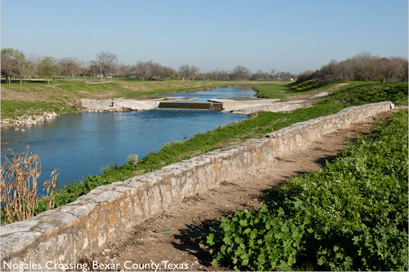
Nogales Crossing
This ford is listed in the National Register of Historic Places. Archaeologist Jake Ivey notes that the boundaries of the mission lands of Nuestra Señora de la Purísima de la Concepción extended to a point called the Nogales Crossing, which he states is at the San Juan Dam on the San Antonio River, and that this spot marks one of the boundaries for Mission San Juan. (National Park Service)
Located: Park Rd, San Antonio, TX 78214
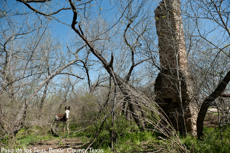
Paso de los Tejas
Materials for the construction of missions were acquired from a series of quarries in this location. There are remnants of structures associated with the period of significance of the trail. (National Park Service)
Rancho de Pérez
This is a state archaeological landmark, a component of the ranch headquarters of Rancho de Pérez, part of the Ignacio Pérez land grant. The ranch was known as the Rancho de Piedra (Stone Ranch). The site is located north of the Medina River and has been preserved and protected by the Pérez family for more than a century. There is a chapel at the cemetery, which was constructed on top of the foundation of the original Spanish Colonial period chapel. Some elements of the original chapel remain.
Time period: late 1700s/early 1800s
Ownership: Cemetery is private (owned by Pérez family descendants); ranch is public (owned by the City of San Antonio).
Sabinitas Crossing
This ford is a state archaeological landmark. The route here crossed the Medina River for the Camino de los Palos, known to the Spanish as Paso Sabinitas. (National Park Service)
Located: 15890 TX-16, San Antonio, TX 78264
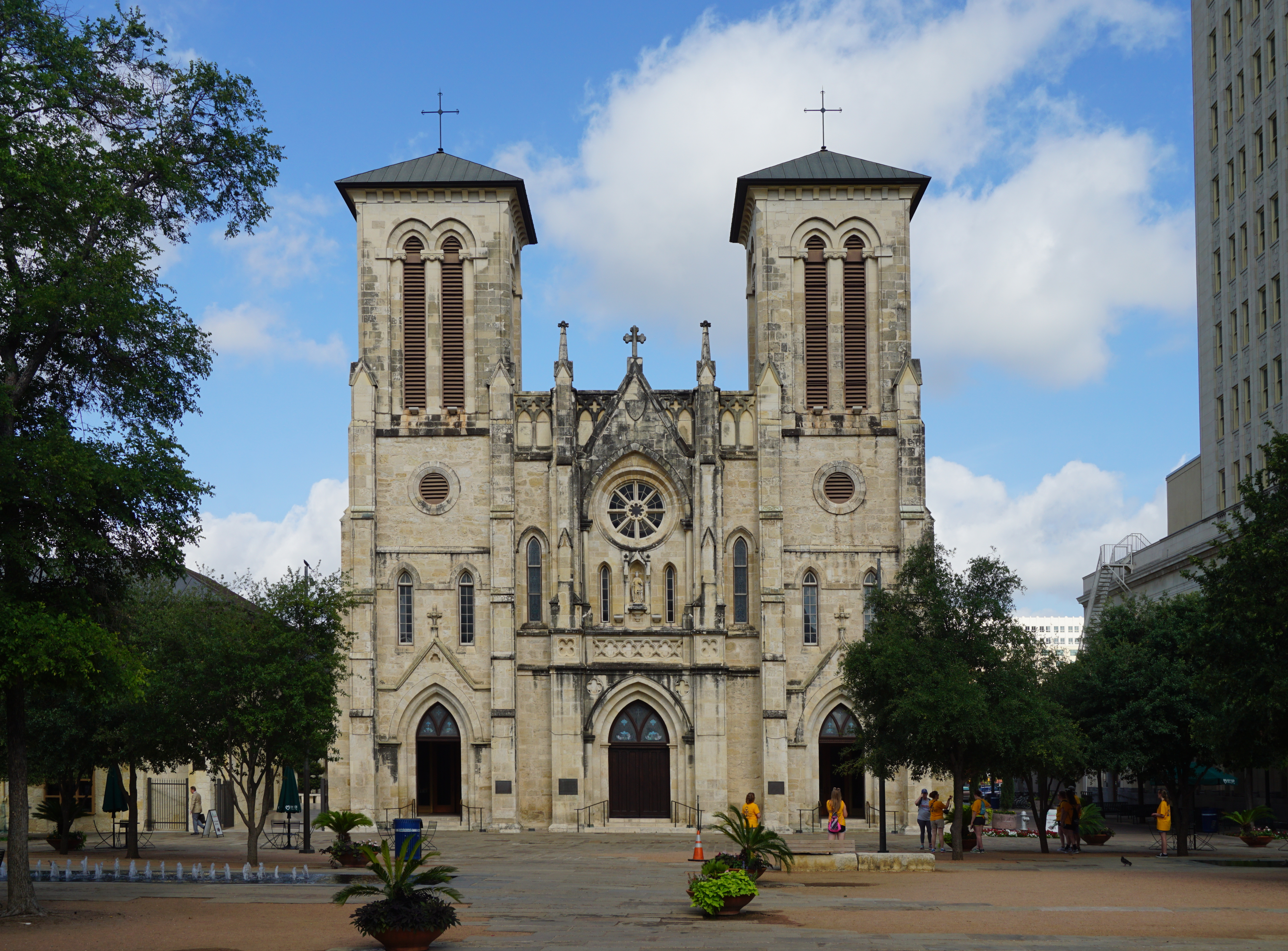
San Fernando Cathedral
The original Church of Nuestra Señora de la Candelaria y Guadalupe was built between 1728 and 1749 as the parish church of Villa San Fernando de Béxar, the first civil settlement in the Spanish province of Texas. By the mid-1860s the population of San Antonio had outgrown the original structure. The present building was begun in 1868 and incorporated the old church. Designed by Francis Girard, the church has twin towers and triple portals in the Gothic Revival style. Renamed the San Fernando Cathedral, it became the seat of the Archdiocese of San Antonio. James Bowie, defender of the Alamo, was married in the original chapel and local tradition maintains that the remains of the defenders of the Alamo are buried in the new section of the cathedral. (National Park Service)
Located at: 115 Main Plaza, San Antonio, TX 78205
Photo Credit: Michael Barera
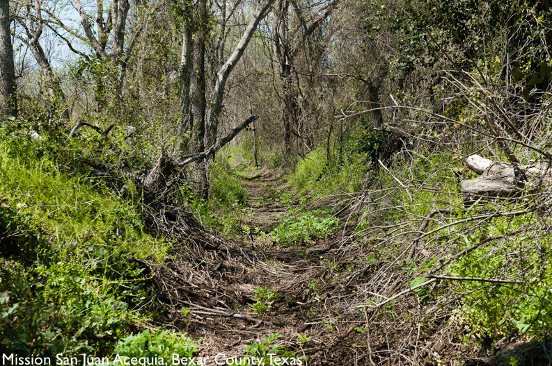
San Juan Acequia Trail
Listed in the National Register of Historic Places, this acequia (irrigation ditch) is associated with Mission San Juan. (National Park Service)
The Acequia Trail’s Northern Terminus is located near Padre Park, and follows the Acequia south to Mission San Juan.
Time period: 1700s
N. Terminus Located: 6370 S Presa St, San Antonio, TX 78223
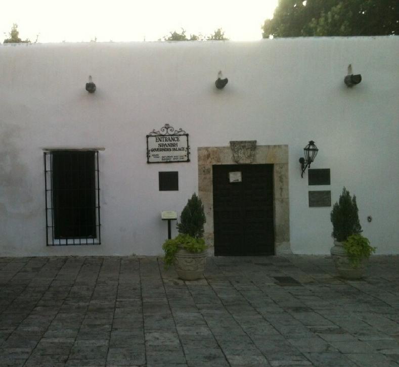
Spanish Governor’s Palace
The Spanish Governor’s Palace, a National Historic Landmark, is the last visible trace of the Presidio San Antonio de Béxar and the only remaining example in Texas of an aristocratic 18th-century Spanish Colonial town house. Plans for the building originated as early as 1722. Upon its completion in 1749, the house served as the Commandancia, or residence and working office of the Captain of the Presidio. Later, it became the home of the Spanish governors who lived in San Antonio. The Spanish built the Presidio of San Antonio de Béxar to protect the area’s missions, including the San Antonio de Valero Mission (The Alamo) and the missions in San Antonio Missions National Historical Park, as well as the growing Spanish colony. The Spanish Governor’s Palace is all that is left of this important and influential presidio. (National Park Service)
Located at: 105 Plaza de Armas, San Antonio, Texas, 78205
Photo Credit – DLS Texas
Photo Credit – DLS Texas
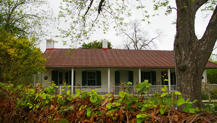
Yturri-Edmunds Historic Site
In the early 19th century during the era of Mexico’s General Colonization Law, Manuel Yturri de Castillo was given a land grant on property once owned by Mission Concepcion. He was thought to have been born in Spain, but immigrated to Mexico. There he was employed by Spanish merchants who transferred him to San Antonio. In 1821, he married Maria Josefa Rodriguez, whose family were among the first Canary Islanders to arrive in the area in 1731. Upon his death, his property passed to his heirs. His granddaughter Ernestine Edmunds bequeathed the property in the historic site to the San Antonio Conservation Society (SACS), which took possession of it in 1961. (Wikipedia)
Located at: 251 Yellowstone St, San Antonio, Texas, 78210
Photo – Sanantonio.gov
San Marcos
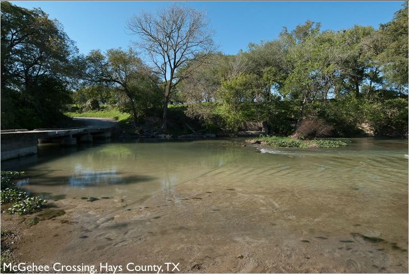
McGehee Crossing
“The Camino Real, also known as the Old San Antonio Road and the King’s Highway, followed a route from Nacogdoches to the Rio Grande. Louis Juchereau de St. Denis (1676-1744) traveled the route to establish trade between the French in Louisiana and the Spanish of Coahuila Province on the Rio Grande in 1714.
The first settlement at the San Marcos River crossing of the road was Villa San Marcos de Neve, established by the Spanish in 1808. It was abandoned by 1812 due to the brewing Mexican revolution.
During their colonization efforts in 1820 and 1821, Moses Austin (1761-1821) and his son, Stephen F. Austin (1793-1836), very likely crossed the San Marcos River near this point.
Thomas Gilmer McGehee (1810-1890) settled on the east side of the river on a Mexican land grant about 1846. In 1859 his nephew, Charles L. McGehee, Jr. (1837-1929), acquired 1200 acres of land bordered by the Camino Real and the river. Ten years later he sold the land to his cousin, George T. McGehee (1836-1926). Due to the McGehee family’s association with this historic site, it became known as McGehee Crossing.”
San Marcos de Neve
Intended as part of a chain of defensive settlements stretching from Béxar to Nacogdoches and was personally funded by the Spanish governor of Texas, Manuel Antonio Cordero y Bustamante. Cordero charged Felipe Roque de la Portilla with leadership of the expedition to reestablish a Spanish presence on the San Marcos River, where the San Xavier missions had been temporarily relocated fifty years earlier. Colonists for the San Marcos villa were recruited from south of the Rio Grande rather than from Béxar and Louisiana. The first group of colonists set out from Refugio (now Matamoros) in December 1807 and by February 1808 had settled near the San Marcos crossing. Lt. Juan Ignacio Arrambide was appointed justicia (magistrate) of the town, with power to issue titles to land. Estimates of the villa’s size vary from about fifty to eighty people, including perhaps a dozen families and servants and as many as 1,700 animals-cattle, horses, and mules. A central plaza had been laid out and titles issued to thirteen town lots when a flood on June 5, 1808, nearly wiped out the nascent community.
The colony held out for several years, but harassment by Comanche and Tonkawa Indians finally forced its abandonment in 1812. (National Parks Service)
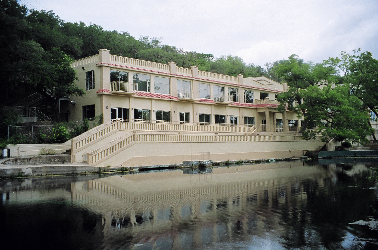
San Marcos Springs
The San Marcos Springs is an area of artesian outflow from the Edwards Aquifer along the Balcones Escarpment. More than 200 springs flow from three large fissures and other smaller openings in the rock. The springs provide most of the water for the San Marcos River, which flows southward from the springs’ location.
In 1849, former Republic of Texas vice president Edward Burleson built a dam just downstream from the springs; the resulting lake, known as Spring Lake, inundated the springs.
Located: 201 San Marcos Springs Dr, San Marcos, TX 78666
Texas State University
Texas State University